opertuns mundi
A Single Digital Market for Industrial Geospatial Data AssetsGeospatial data is the cornerstone of any application, service, and product even remotely related to our physical surroundings. Despite the significance of geospatial data for our Data Economy, an assessment of the current market landscape reveals a gap between policy intentions and subsequent industrial uptake. The market of geospatial data owners and consumers on an EU setting remains disjoint and fragmented, with assets difficult to discover, assess, obtain, and integrate in a cross-domain, cross-border, and cross-lingual manner from most prospective consumers of the geospatial value chain. This status quo demands an EU-wide intervention targeted on delivering a Digital Single Market for proprietary geospatial data addressing the heterogeneity, disparity, and fragmentation of geospatial data products in a cross-border and inclusive manner.
OpertusMundi will deliver a trusted, secure, and highly scalable pan-European industri
Project coordinator is the Athena RC while the participants are: TU Delft, Fraunhofer, GET, Sinergise, CMG Legal, AZO, WIGEOGIS, Georepublic and Roleplay.
The project started on 1/1/2020, with a total duration of 36 months. The total EU funding is 4.71 MEuro.

For more information visit the web site: http://www.opertusmundi.eu
LIFE ASTI
GEOSPATIAL ENABLING TECHNOLOGIES participates at the implementation of the project “Implementation of a forecAsting System for urban heaT Island effect for the development of urban adaptation strategies – LIFE ASTI” under the LIFE 2014-2020 Programme / Subprogram Climate Action / LIFE 2017 Call. Grant agreement reference: LlFE17 CCA/GR/OOOI08.
The partners for the implementation of this project are:
- Αριστοτέλειο Πανεπιστήμιο Θεσσαλονίκης (coordinator beneficiary)
- Azienda Sanitaria Locale Roma 1
- Geospatial Enabling Technologies
- Institute of Atmospheric Sciences and Climate National Research Council of Italy
- Municipality of Thessaloniki
- Sympraxis Team P.C.
LIFE ASTI aims to the design and pilot implementation of a set of prediction systems for short-term prediction of the Urban Heat Island effect during the thermal incidents for the consequences in health in two Mediterranean cities, Thessaloniki and Rome. Prediction systems will be also used for the evaluation of future climate change scenarios impact on Urban Heat Island over Thessaloniki and Rome in order to quantify the result of promoting mitigation plans to combat the impact of the same problem for the two selected cities. This will lead to the development of strategies for better adaption and mitigation of Urban Heat Islands effects during thermal incidents, for reducing the risk of heat-induced incidents in metropolitan areas and for better implementation of energy efficiency policies in European cities.
The project is funded by the European Union at 60%, while the remaining 40% is covered by each partner’s own resources.

Urban Heat Island dashboard
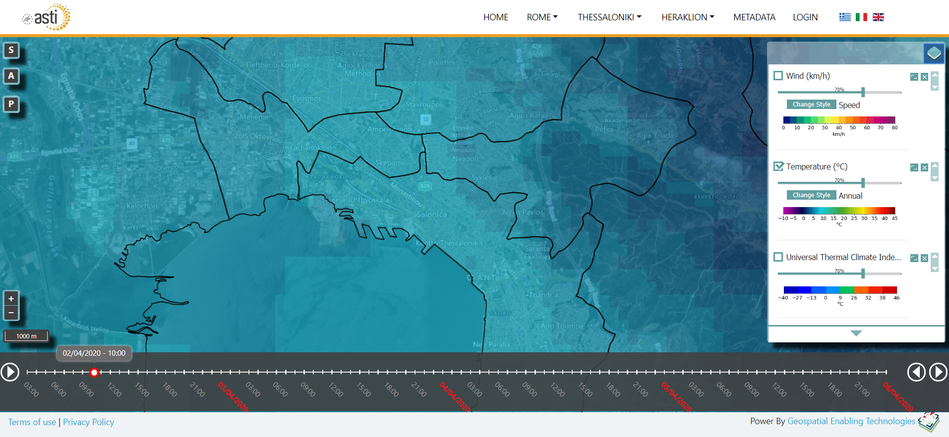
Interactive Map of meteorological forecasting parameters

For more information visit the web site: https://lifeasti.eu/
MUSEION TOPOS
GET participates at the implementation of the project “MuseionTopos” – Project code: Τ1ΕΔΚ-01571 under the framework “RESEARCH – CREATE – INNOVATE” of the Operational Programme “Competitiveness Entrepreneurship Innovation” (EPAnEK 2014-2020), Partnership Agreement 2014-2020.
Cooperation between:
- Products and Systems Design Engineering department – Aegean University
- Piraeus Bank Group Cultural Foundation
- GEOSPATIAL ENABLING TECHNOLOGIES
- DOTSOFT S.A.
Given the huge cultural reserve of Greece, potential applications of interactive systems in heritage are inexhaustible. The proposed project ‘Mouseion Topos’ pursues a particular contribution to settlements and museums of the Aegean, which are characterized by exceptional architectural heritage, industrial tradition, artisanship and craftsmanship. The particular settlements (and islands) of the Aegean have a low number of visitors and tourists for a long period of time within a year; they recently have absorbed great pressure from the refugee (Lesvos & Chios) and economic crisis (Tinos); while their museums are not always in vivid interaction with them. The constant connection of these peripheral museums to the settlements and the islands creates significant benefits for the local communities, tourism, education and learning. The proposed project aims to connect the PIOP museums to the settlements through interactive gamified systems that will exploit mobile and kinesthetic technologies that will emphasize to the promotion of architectural heritage and the intangible tradition of craftsmanship. The main objectives of ‘Mouseion Topos’ are: (a) Digitization and documentation of the architectural heritage of settlements (according to the HERMES methodology and system) and of selected museum exhibits (emphasis on 3D artifacts), (b) Connection of the museums to the settlements through guided gamified tours to visitors, (c) Elevation of the intangible tradition of craftsmanship through kinesthetic simulation games of digital (re)constructions, (d) Assurance of sustainability of project results through various elements like: human-centered approach (co)design thinking and practice, content sharing with Europeana, creation of MOOCs (Massively Open Online Courses), scientific publications, sustainability plan. After the end of this project, each museum will be an innovation cell fully integrated to the settlement. Voth the PIOP foundation and the HERMES system have been awarded with the Europa Nostra award for their contribution to cultural heritage. The proposal has the support of the municipalities of Chios, Lesvos and Tinos (letters of support)
The project is co-financed by the European Union and the European Regional Development Fund.

For more information visit the web site: http://www.mouseion-topos.gr/
KASTOM
GET participates at the implementation of the project “Innovative system for air quality monitoring and forecasting” (ΚΑΣΤΟΜ – Project code Τ1ΕΔΚ-01697) under the framework “RESEARCH – CREATE – INNOVATE” of the Operational Programme “Competitiveness Entrepreneurship Innovation” (EPAnEK 2014-2020), Partnership Agreement 2014-2020.
The project is co-financed by the European Union and the European Regional Development Fund.
Cooperation between:
- Atmospheric Environment Monitoring and Predicting research services – Interdisciplinary Research and Innovation Center / Aristotle University of Thessaloniki
- Environmental Chemical processes, Chemistry Department / University of Crete
- GEOSPATIAL ENABLING TECHNOLOGIES
- DOTSOFT S.A.
Τhe project aims to develop a versatile and flexible air quality monitoring and forecasting system. To date, systematic monitoring of air quality has been carried out on the basis of a small number of stations in large urban areas, while air quality forecasting is carried out only as a research activity (as opposed to other environmental forecasts such as weather or wave forecasting). KASTOM therefore aims to meet this need by providing the necessary environmental information and advice to stakeholders and
citizens via proper hardware & software infrastructure, scientific expertise and computational excellence:Internet of Things-AQ mocrosensor network, advanced air quality modeling, emission data based on remote sensing and state-of-the art modelling, web-based and mobile environmental information services, service as SaaS (Software as a Service) or PaaS (Platform as a Service) For the detailed description and forecasting of air quality, KASTOM combines the following:
• three-dimensional air quality models (WRF / CAMx),
• innovative models for anthropogenic and natural emissions (MOSESS / NEMO),
• updating emissions using satellite data,
• microsensor networks, and,
• computational intelligence methodologies.

For more information visit the web site: https://air4me.eu/
MARRE
GET participates at the implementation of the projectMARine monitoring system of the Hellenic Seas using REmote sensing satellite data and in-situ measurements (MARRE – Project title: Τ1ΕΔΚ-02966) under the framework “RESEARCH – CREATE – INNOVATE” of the Operational Programme “Competitiveness Entrepreneurship Innovation” (EPAnEK 2014-2020), Partnership Agreement 2014-2020.
Cooperation between:
- Hellenic Center for Marine Research
- Aegean University – Department of Marine Science
- GEOSPATIAL ENABLING TECHNOLOGIES
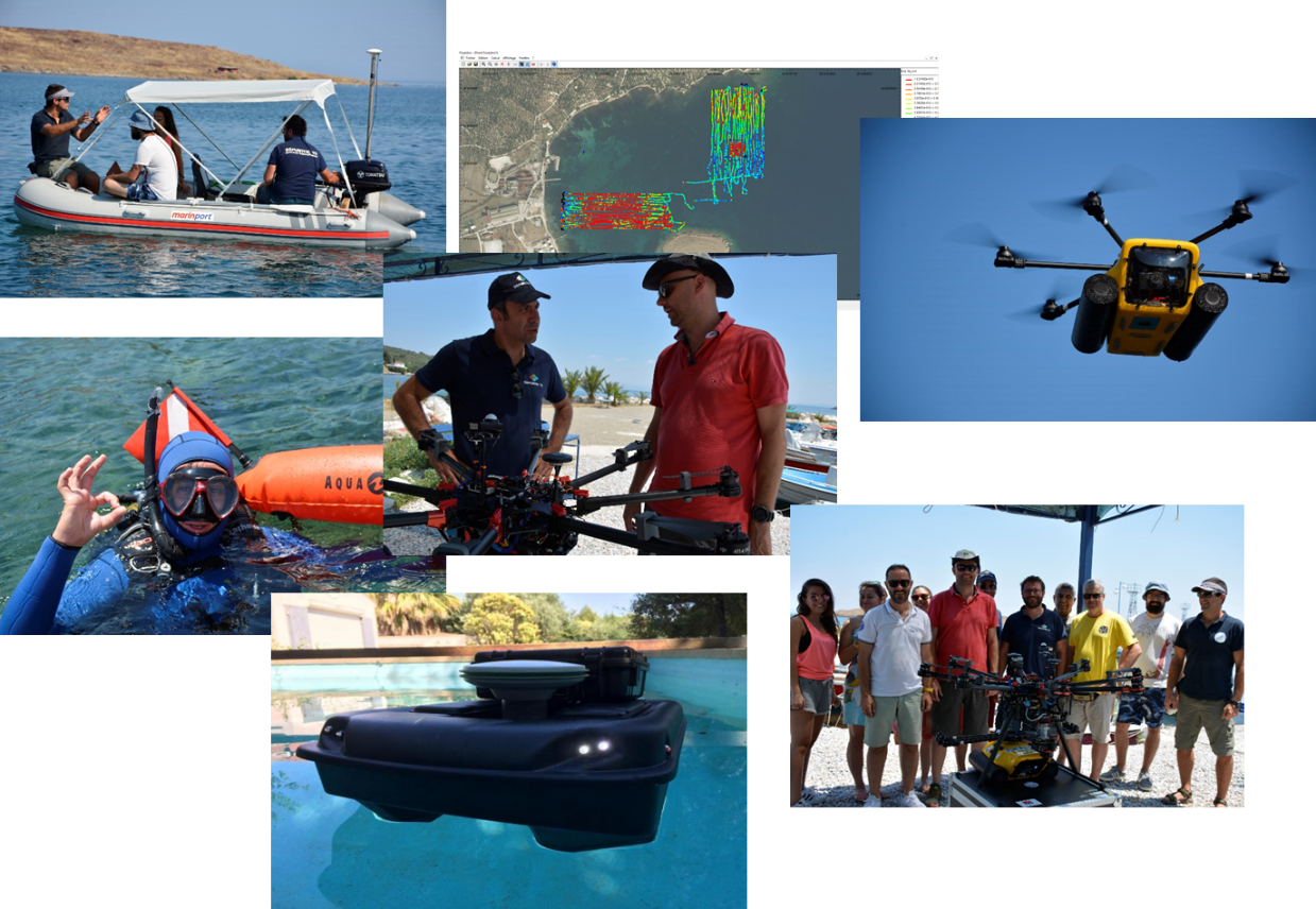
The objective of the research proposal is the development of an open source GIS system for monitoring the marine environment by using satellite remote sensing data combined with field measurements (historical and real-time data). The development of such a system for Greece stems from the need to support national policies in areas of high interest such as the environmental status of the coastal zone and the wider marine environment. The project will develop innovative products to monitor the status of the marine environment using free satellite observation data.
These new products will provide information on water quality and will be derived from the in-situ measurements of the participating institutions as well as from available data at European repositories. In particular, using high-resolution satellite data such as Sentinel data in combination with in-situ measurements at Greek seas, essential environmental parameters such as chlorophyll concentration and turbidity will be assessed. The combined use of satellite data and in-situ measurements will evaluate and improve existing empirical algorithms. As a result, the derived products will be adapted to local conditions and the specific features of Greek seas. Importance will be given to the monitoring of the marine biodiversity by the mapping and the monitoring of the Posidonia meadows.

The MARRE platform architecture
The project is co-financed by the European Union and the European Regional Development Fund.

For more information visit the web site: http://marre.gr/
ppCity
GET participates in the implementation of the research project with the title “Integrated System for the Spatial Decision Support and Participation”, acronym ppCity, project code: Τ1ΕDΚ-02901 and MIS code 5029727 under the framework of the Action “RESEARCH – CREATE – INNOVATE” of the Operational Programme “Competitiveness Entrepreneurship Innovation” (EPAnEK 2014-2020), Partnership Agreement 2014-2020.
Members of project consortium are:
- DOTSOT S.A.
- GEOSPATIAL ENABLING TECHNOLOGIES
- COMMONSPACE
- SOCIALITY
The project aims at the development of an Integrated Spatial Decision Making & PP system for designing and monitoring projects and other actions at different scales (neighborhood-wide or/and city-wide), centered on citizenship, environment and quality of life. The engagement and participation of the “general public” and the users of the public space is essential for the whole process. The above-mentioned system consists of three (3) platforms for management, interaction and analysis. The final product is a modular system. The core is the PP platform, with the other two supporting and reinforcing it, but also being able to stand-alone. Moreover, infrastructure to integrate data from IoT sensors will be developed.
During the project, the project team will develop:
- Platform 1 – Data Collection & Identification of Problems. The basic infrastructure that gathers the needed data for the operation of the planning and decision-making process. The purpose of this platform is to gather and to manage environmental and quality of life city data. It works practically as a data hub: It exploits existing data and services through interoperability procedures, allows the enrichment of the hub with new data sets and supports sharing and reusing through the web.
- Platform 2 – Participatory Planning / ppGIS. It is a unique system of participatory planning & design implementation including several innovative features. The platform provides tools, knowledge and concrete steps for equal and meaningful participation of citizens and users. The proposed projects and actions are “forwarded” to the users through a targeted and structured communication campaign to ensure increased participation of appropriate population groups. It also supports processes for the analysis and selection of appropriate design solutions, proposals and ideas. Multicriteria analysis algorithms prioritize interventions as well as the weight of the participants’ opinion, who is invited to participate in all the phases of the process.
- Platform 3 – Monitoring Indicators / Dashboard. This platform acts as a tool for monitoring and evaluating emerging issues and possible solutions. It contains an extensive pool of life quality indicators based on European standards. It is a valuable tool for analyzing the “state of the art” of a municipality: It produces comparable results, quantitates quality data, and supports each organization / institute / body in its strategic planning as well as in funding and monitoring the implementation of programs and projects.
- Unified System. It aims at completing the three subsystems, operating control and producing documentation of the integrated system.
Through this project, collaborating companies will incorporate new knowledge and innovation into the services and products they already provide. Therefore, the project will strengthen them by increasing their competitiveness and research potential while creating benefit and new employment. Furthermore, the project can work as an active link between research and economic growth / social needs, thus contributing positively to the national economy and Greek society’s well-being.

The project is co-financed by the European Union and the European Regional Development Fund

For more information visit the web site: https://ppcity.eu/
AMOS
GET is funded for the implementation of the research proposal «Shallow Water Aquatic Monitoring using Acoustic Sensors and Satellite Images (AMOS)» under the program “NEPTUNE: New Cross Sectoral Value Chains Creation across Europe Facilitated By Clusters for SMEs’ Innovation in Blue Growth” which has received funding by the research and innovation program of European Union, Horizon 2020 (No. Of grant agreement: 691554), in which Greece participates with Corallia.
GET proposal was submitted in cooperation with French company Semantic-TS. The proposal is about the development of an innovative system for monitoring aquatic environment (Bathymetry and classification of marine ecosystems, recording of fishing potential) of coastal water. The system will be based on acoustic monitoring technology by Semantiv – TS for this project, it will be adapted into USV system, offering capacity to easily collect data even in very shallow water. These data will be integrated into the innovative platform for geospatial data diffusion of GET where additionally open satellite data Sentinel or other free earth observation data, like Copernicus, will be provided.
The platform will be developed exploiting GET’s technical expertise in open data and disposal/projection of spatial data. Specifically, technologically the solution will be based on open source software GET SDI PORTAL.The solution will be tested in pilot process in French and in Greece. The results will be accessible for the public via the web application which will be developed for this reason.
GET is, since 2015, member of the si-Cluster,the Greek dynamic and constantly developing gold labeled cluster activated into space technologies, participating in actions for the development of sustainable products into space technologies and applications.
NEPTUNE PROJECT has received funding by the European Union’s Horizon 2020 Program under Grant Agreement 691554
Study on the relation of radioactive pollution and satellite observations of marine parameters and comparative analysis on a Geographic Information System

GET participates at the Industrial Research Fellowship program of National Centre for Scientific Research “Demokritos” supporting the doctoral research of the PhD candidate Georgia Mavrokefalou for the implementation of the project “Study on the relation of radioactive pollution and satellite observations of marine parameters and comparative analysis on a Geographic Information System”. GET in cooperation to the Environmental Radioactivity Lab, with Dr. Eleni Florou as supervisor researcher, and the Aristotle University of Thessaloniki, supports the new researcher Georgia Mavrokefalou at the 4 years Research PhD program with industrial orientation.
Through the program, the researcher will carry out her research in an innovative research field, where her results apply and give solutions to industrial problems, reinforcing in this way Research Department of small and medium-sized – and not only – enterprises in Greece, and promoting their competitiveness in national and European level.
GET supports doctoral research of Mrs Mavrokefalou who will carry out a research program directly connected to the interest of GET in Environmental Geo-Informatics.
The Industrial Research of Fellowship program is implemented under the generous donation and support of Stavros Niarchos Foundation (SNF). The program is an institution highly prevalent in Europe the last years due to the advantages presented in relation to purely academic ones, such as access to industrial scale equipment and environment as well as job prospects thereafter.
SLIPO
GET participates at the new Research project SLIPO: Scalable Linking & Integration of Big POI Data under the Horizon 2020 frame. Partners for the implementation of the project are :
- Institute for the Management of Information Systems (part of Athena Research and Innovation Centre in Information, Communication and Knowledge Technologies) (Greece)
- Institute for Applied Informatics (InfAI) e.V. (Germnay)
- Fraunhofer Institute for Intelligent Analysis and Information Systems IAIS (Γερμανία)
- Tom Tom (Germany)
- WIGeoGIS (Austria)
- GEOSPATIAL ENABLING TECHNOLOGIES (Greece)
SLIPO’s objective is to develop a comprehensive and vendor-agnostic ontology for POI data, allowing to model and represent multi-faceted and enriched POI profiles. This accommodates and extends existing POI formats, providing a uniform and semantically-rich model for assembling POI data from heterogeneous sources.
You can see here the project’s information leaflet.
For more information visit the web site: http://www.slipo.eu/
Publica Mundi
GET participated at the reconstruction and the development of the new www.geodata.gov.gr application as part of the research project PublicaMindi. The projects has been successfully completed and funded by the 7th Framework Program. Our partners in this project are:
- Institute for the Management of Information Systems of the “Athena” Research and Innovation Centre in Information, Communication and Knowledge Technologies
- Rasdaman
- GeoLabs
Basic objectives of the project were:
- Extension of open data catalogues for integrated publishing support, geospatial data lifecycle diligence and management,
- Tools development and integration permitting multilinguality interconnection and management regarding geospatial data in cross-borders framework
- Scalable/expandable technologies and services for on-demand creation and reuse of maps with the use of open geospatial data
- Analysis services development for the accurate control of open geospatial data use, scalable/expandable technologies and reusable data APIs development for querries support and open geospatial data editing and analysis.

GEODATA.gov.gr was developed as part of the Publica Mundi activities
The development of the project was based exclusively on Free and Open Source Software and the architecture is presented below.

![]() This project has received funding from the European Union’s FP7 research and innovation programme under grant agreement No 609608
This project has received funding from the European Union’s FP7 research and innovation programme under grant agreement No 609608
For more information visit the web site: http://www.publicamundi.eu/
Aquanet
GET participated at the research project “City Water Management Systems and Water Distribution Network Monitoring – AquaNet” (code 11ΣΥΝ_6_925) of the General Secretariat for Research and Technology under the framework “Cooperation 2011 – Partnerships of Production and Research Institutions in Focused Research and Technology Sectors” of the Operational Programme “COMPETITIVENESS AND ENTREPRENEURSHIP”.
Our partners for this project were:
- Telecommunications Systems Institute (TSI) of Technical University of Crete ( TUC)
- Radiocommunications Laboratory (RCL) of Physics department of Aristotle University of Thessaloniki (AUTH)
- Zalikas Liontas Techniki
- Municipal Enterprise of Water and Sewage of Chania
The project aims to develop a low-cost and large-scale pilot WSN for water management that will be able to augment the existing monitoring and management functionality of the Municipal Enterprise of Water and Sewage of Chania (DEYAX). Particular emphasis will be given on cognitive radio principles, not currently supported by commercial Zigbee-based WSNs and relevant standards. Such an approach is crucial for successful large-scale, city-wide deployment, given that the license-free Industrial Scientific Medical (ISM) frequency bands are usually crowded. The consortium will exploit its significant know-how on renewable energy sources, both solar and wind, in order to design autonomous micro-powering of the installed radio terminals and sensors. Furthermore, the project spearheads low-cost sensors appropriate for water level. It is remarked that existing level sensors are usually of high cost and imported. Moreover, the consortium will capitalize on its award-winning experience on in-network processing of acquired (sensed) data, including periodic or streamlined (aggregate) measurements. In-network processing offers intelligence in the system, while reducing the required communication bandwidth, since redundant information is not re-transmitted. Furthermore, the offered in-network intelligence will simplify the design of sensors, significantly reducing their cost, and will offer resistance to sensor outlier readings. DEYAX will offer the fertile experimentation ground, since a subset of their watering system, including storage/distribution tanks and pipes will be networked with the proposed system. Concrete quantification of the benefits will be performed in conjunction with other WSN-free parts of the watering infrastructure. It is remarked that DEYAX and members of the AquaNet consortium have already successfully collaborated in other applications.
For this project, GET developed application which offers access to project’s geospatial data. Moreover, the application which works as an application client for geospatial data services based on open standards. Basic features and functions are:
- Compatibility with global and widespread used geospatial information standards, like: WMS, WFS, WFS-T, WMTS, CSW
- Multiple different services integration on the same map
- View, download, search and analysis functions
- Metadata catalogues searching
Application development was based on GET SDI Portal.
Adapt2CC

The GET is involved in the implementation of the research project entitled “INNOVATIVE RESEARCH ON THE DEVELOPMENT OF AN URBEN AREAS VULNERABILITY INDEX IN CLIMATE CHANGE AND THE CREATION OF A MULTI-CRITERIA SYSTEM FOR ASSESSING THE EFFICIENCY MEASURES OF CLIMATE CHANGE ADAPTATION MEASURES” ACRONYM: Adapt2CC – PROJECT CODE T2EDK-02881 under the framework “RESEARCH – CREATE – INNOVATE” of the Operational Programme “Competitiveness Entrepreneurship Innovation” (EPAnEK 2014-2020), Partnership Agreement 2014-2020.
Adapt2CC is implemented by a collaborative group of three (3) partners: two research institutes (the Department of Environmental Physics from the National and Kapodistrian University of Athens and the Institute for Environmental and Sustainable Development Research of the National Observatory of Athens), and one company, GET.

The relationship between cities and climate change is multiple as the way a city develops affects heat flows, evaporation rate, urbanization characteristics, spatial distribution and intensity of anthropogenic heat sources and other factors which cumulatively deteriorate the thermal environment and intensify the rise in air temperature due to climate change. At the same time, the increase in the intensity and frequency of heatwaves and the deterioration of the thermal comfort in an urban area has a severe impact on the health of citizens, while also leads to increased cooling energy consumption, especially for buildings with low energy efficiency.
Based on the above, it is necessary to estimate the vulnerability of urban areas to climate change particularly regarding the deterioration of the thermal environment.
The scope of the project is to organize urban areas in Urban Climate Zones, to develop a Climate Change Thermal Vulnerability Index and to estimate the vulnerability per Urban Climate Zone in order to assess the effectiveness of the climate change adaptation measures.
The platform produced will allow for the first time in Greece to study climate change and its effects in a systematic and efficient way, with an emphasis on the thermal environment, especially in the urban areas where the largest population is concentrated.
The project is co-financed by the European Union and national resources through the OP. Competitiveness, Entrepreneurship & Innovation (EPAnEK, NSRF 2014-2020) of the Ministry of Development and Investment.

More information on the website: https://www.adapt2climate.gr/
Aquasafe

The GET is involved in the implementation of the research project entitled “Towards a precision aquaculture geoinformation system” ACRONYM: AQUASAFE – PROJECT CODE T2EDK-02687 under the framework “RESEARCH – CREATE – INNOVATE” of the Operational Programme “Competitiveness Entrepreneurship Innovation” (EPAnEK 2014-2020), Partnership Agreement 2014-2020.
AQUASAFE is implemented by a collaborative group of four (4) partners: two research institutes, the Department of Marine Sciences of the University of Aegean and the Hellenic Centre for Marine Research, and two companies, PLAGTON and GET.
Aquaculture is a rapidly growing sector worldwide with Greece holding a leading position in the industry, maintaining about 60% of European production and 40% of global production. Therefore, promoting the sustainable development of the industry is a key priority for both the country and the EU, as it is one of the main pillars of the Blue Growth strategy for Greece.
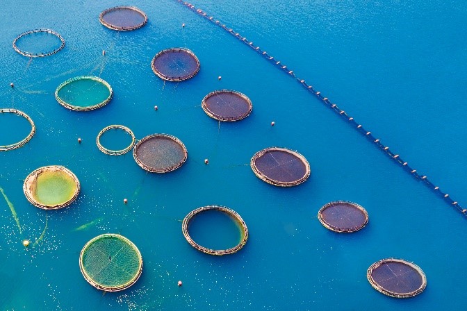
Aquaculture today, in parallel with its rapid growth, needs to face significant challenges in the coming years, such as reducing cost production, automating unit management processes and increasing water areas for exploitation. All the above must be implemented in a sustainable context and in harmonious coexistence with other activities in the coastal zone (e.g. tourism). One of the proposed solutions in this direction is the relocation of units from areas near land to offshore Organized Aquaculture Development Areas (POAs). At the same time, following the trend for “precision culture”, there is a growing interest for research in the precise definition of the most low-cost and effective technical management tools and for the ability to control and monitor aquaculture units, even remotely.
The scope of the project is the synergistic use of Remote Sensing and in-situ data in order to create an integrated system of remote monitoring and early warning of aquaculture. The system can be used by the management body of a POA or by the manager of a large unit and will warn of phenomena that may pose a threat to the unit, directly or indirectly. Examples of such phenomena are the development of harmful toxic blooms, the outbreak of jellyfish and the transport of pathogenic microorganisms and nutrients.
The scope of the project utilizes technologies and methods that are state of the art of IT research. Through automation, the monitoring of the unit and the entire installation area (even in remote or inaccessible places) can be carried out continuously, without the need for the presence of staff, which will significantly reduce the reaction time in case of problem and will reduce travels to and from the installation, for the benefit of production costs and employee safety.
In summary, such a tool will contribute to:
- in decision support
- in the early warning for phenomena that threaten aquaculture
- in remote monitoring at multiple levels
- in risk assessment and prevention
The project is co-financed by the European Union and national resources through the OP. Competitiveness, Entrepreneurship & Innovation (EPAnEK, NSRF 2014-2020) of the Ministry of Development and Investment.

FarmaDSS

The GET is involved in the implementation of the research project entitled “Development of an innovative cotton production support system using satellite remote sensing, IoT sensors and advanced agricultural models” ACRONYM: FarmaDSS – PROJECT CODE T2EDK-00746 under the framework “RESEARCH – CREATE – INNOVATE” of the Operational Programme “Competitiveness Entrepreneurship Innovation” (EPAnEK 2014-2020), Partnership Agreement 2014-2020.
FarmaDSS is implemented by a collaborative group of two (2) companies, Farmacon and GET.
The agricultural sector, under the pressure of both free competition and limited production factors, must increase the competitiveness of its products, while at the same time making the best use of the available inputs. In the context of internationalization of trade and commerce, farm decision-making at farm level and regional level are mainly dependent on a wealth of information and data (such as research results, market structure information, etc.). Therefore, the acquisition of information-data in agriculture is closely related to making several decisions, as they are necessary tools to achieve a result.
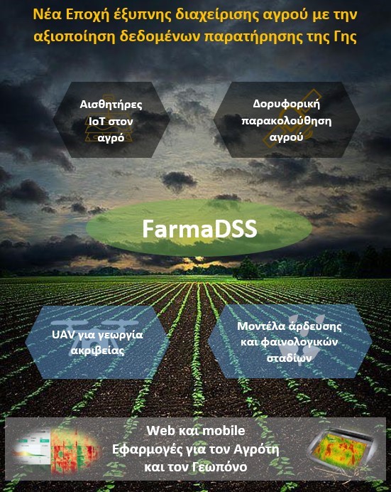
The goal of the FarmaDSS project is to develop a modern Decision Support System (DSS). It takes the form of a cloud application that is a valuable advisory tool for the agronomist and the farmer. The app combines the use of innovative data retrieval tools from IoT sensors, data, and remote sensing applications, and predictive entomological models, coupled with the use of electronic pheromone traps to monitor insect populations. The target is to support, the soonest, decisions for the management of the two most significant, time-consuming, and costly problems in cotton production, pest control of Helicoverpa armigera (green worm) and irrigation.
The main goal is to make decisions directly on the management of cotton cultivation using a quick response and high precision tool that is easy to use by both experts and producers, in order to provide solutions for:
- timely intervention using chemical means in the event of a green worm infestation; and
- timely and proper management of crop irrigation.
The project is co-financed by the European Union and national resources through the OP. Competitiveness, Entrepreneurship & Innovation (EPAnEK, NSRF 2014-2020) of the Ministry of Development and Investment.

More information on the website: https://farmadss.gr/
inAthens

The GET is involved in the implementation of the research project entitled “ Invisible Athens Stories” ΑΚΡΩΝΥΜΙΟ: IN-ATHENS – ΚΩΔΙΚΟΣ ΕΡΓΟΥ T2ΕΔΚ-01696 under the framework “RESEARCH – CREATE – INNOVATE” of the Operational Programme “Competitiveness Entrepreneurship Innovation” (EPAnEK 2014-2020), Partnership Agreement 2014-2020.
IN-ATHENS is implemented by a collaborative group of five (5) partners: MELISSA publishing house, GET company, Commonspace, HERMES and DIPYLON.

The main object of the project “IN-ATHENS: Stories of an invisible Athens” is the transformation of an extraordinary historical value archival material for the city of Athens into a series of digital applications and innovative co-design tools. The aim is to bring forward the ancient and modern cultural heritage of Athens together with the stories of its people within the city’s streets and buildings. Walking through storytelling in the successive cities (from ancient times to modernity) is a cognitive and educational journey into the living history of the city. The stories of people, the everyday life and the events that determined the fortune of the city, will be portrayed in an ongoing dialogue. This dialogue will be digital and interactive through the partnership of architecture, history, archeology and digital technology thus composing an attractive story for Athens on:
- A dialogue between the ancient past (archaeological remains) and the modern history (classicism, 19th, 20th c.) of Athens.
- A dialogue between the buildings (elements of human intervention) and the Athenian natural landscape.
- A dialogue between the buildings and the people; oral testimonies and interviews of locals in specific neighborhoods of Athens.
- A dialogue between the different mappings of Athens (from the first cartographic backgrounds to the current digital maps).
During the project a rare archive of material will be digitized. In particular: old photographs, topographical maps, aerial photos, drawings, newspapers and paintings owned by MONUMENTA; town maps – historical maps and archaeological excavations results that have been archived by DIPYLON; texts, photos and everyday stories about Athens, part of the rich publishing collection of MELISSA. The structured digital archive and the original digital repository created by GET will be a valuable source of information for the creation of digital online and mobile narratives. The information will feed HERMeS to develop mobile thematic navigation applications for the ‘Invisible Athens’ as well as special tours for children and adults. Finally, COMMONSPACE will mobilize and inform citizens with a focus on children and learning through participatory design / planning, experiential workshops and other innovative and co-design tools.
The project is co-financed by the European Union and national resources through the OP. Competitiveness, Entrepreneurship & Innovation (EPAnEK, NSRF 2014-2020) of the Ministry of Development and Investment.

YANTAS


The GET is involved in the implementation of the research project entitled “Prototype system for assessing and mapping vulnerability and disaster risk due to severe weather in Greece” ACRONYM: YANTAS – PROJECT CODE T2EDK-01108 under the framework “RESEARCH – CREATE – INNOVATE” of the Operational Programme “Competitiveness Entrepreneurship Innovation” (EPAnEK 2014-2020), Partnership Agreement 2014-2020.
YANTAS is implemented by a collaborative group of two (2) companies: INTERAMERICAN and GET.
The insurance industry has, quite early, realized the effects of climate social change, on the risk of weather. For this reason, it has focused on recording and monitoring catastrophic weather events and their consequences, emphasizing on their implications for the insurance industry and its sustainability. However, the frequency and intensity of severe weather events, as well as the amount of financial losses of such phenomena, fluctuate sharply. This fact concerns Greek insurance companies insofar as they are called upon to manage insurance risks of this nature. In addition, the existing actuarial insurance studies in our country are based on vulnerability and risk indicators concerning other European countries, although the European Insurance Agency has stated, as an urgent need, the creation of specialized risk and weather risk studies based on local specific climatic characteristics of each country (IE, 2018).
The proposed project aims to meet a significant need of the Greek insurance market, which is related to the lack of data at local-scale, concerning the vulnerability of geographical zones related to catastrophic weather phenomena and the risk of these phenomena. For this purpose, a prototype system (YANTAS system) for estimating and mapping vulnerability and destructive risk due to severe weather events at very high spatial resolution (Postal Code level) will be developed for the first time in Greece. The information provided by the system will be based on the severe weather phenomena intensity and frequency of occurrence, combined with the resulting economic losses, and in relation to demographic and socio-economic parameters (population, urbanization, wealth, etc.).
The development of YANTAS system comprises of the following steps:
- Development of a database consisting of meteorological, economic, demographic, environmental and social data for weather events that caused damages during the period 2001-2019.
- Data processing for the
- computation of the vulnerability to weather risk and
- the assessment of weather risk at each geographical zone.
- Mapping of the local vulnerability and risk indices.

The results of YANTAS system will be exploited by the INTERAMERICAN insurance company in order to:
- Carry out an analysis of the company’s exposure to financial risks related to the spatial distribution of weather hazards in Greece.
- Establish appropriate vulnerability and risk indicators, aiming to elaborate a new pricing policy on insurance premiums and compensations for weather disasters.
At the same time, the dissemination and distribution of the YANTAS system data through the online platform that will be developed within the project is expected to lead to increased information and public awareness concerning the riskiness of weather phenomena and the vulnerability of specific regions. Furthermore, the dissemination of research results to the scientific community is expected to significantly contribute to the study of natural disasters in Greece and to support further research in the field of designing civil protection measures.
The project is co-financed by the European Union and national resources through the OP. Competitiveness, Entrepreneurship & Innovation (EPAnEK, NSRF 2014-2020) of the Ministry of Development and Investment.

eLEONAS ppWebGIS
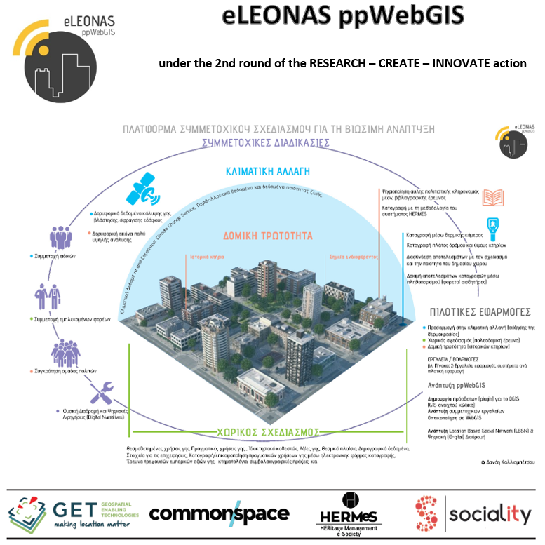
GET coordinates the new research project “eLEONAS ppWebGIS: PARTICIPATORY PLANNING PLATFORM FOR SUSTAINABLE DEVELOPMENT” in the framework of the Joint Action of State Aid for Research, Technological Development “Competitiveness, Entrepreneurship and Innovation (EPANEK)”, NSRF 2014 – 2020. The project is implemented by a collaborative group of four (4) partners: the cooperatives Commonspace and Sociality, HERMES and GET company.
The scope of the proposed project is the design and development of participatory planning processes and tools in order to support spatial decision-making development, planning and intervention in urban areas facing special challenges and / or opportunities. The aim is to introduce participatory planning in Integrated Sustainable Development Planning, as a “system” that provides on multiple scales, while responding directly to the needs of the public.
The participatory processes that are emphasized during the development of the proposed project are aimed at:
- Prediction, where the involvement of experts is crucial for the best possible approach and reduction of uncertainty. Dedicated application in climate change adaptation plans.
- Planning, where the involvement of the competent and the involved bodies is important for the success of the development and the spatial planning. Dedicated application in urban analysis of integrated spatial planning.
- Prioritize risks, measures and actions, where the combination of public participation, experts and stakeholders judges the effectiveness of interventions. At the same time, people’s personal narratives, as well as community memories, play an important role in restoring and preserving cultural heritage (material and intangible). Dedicated application in prioritization of structural vulnerability of buildings, in order to preserve cultural heritage.
Tools and methodologies for environmental, development, spatial and cultural planning are introduced through the participatory planning platform for sustainable development. The necessary communication actions that support the participatory processes are structured around two (2) innovative applications:
- a Spatially Identified Social Network – Spatial Forum and
- a Φ-gital application, i.e. a digital route in natural space, for the promotion and participation of the public in spatial planning issues.
The tools will be tested around three pilot applications in the area of Eleonas, Attica, while supporting toolboxes will be created aiming at being able to apply in other areas of Greece, with similar characteristics.
The project is co-financed by the European Union and national resources through the OP. Competitiveness, Entrepreneurship & Innovation (EPAnEK, NSRF 2014-2020) of the Ministry of Development and Investment.

5D ARCH AID

GET coordinates the new research project “5D ARCHitectural AIr Documentation – 5D ARCH AID” in the framework of the HORIZON2020 European project UFO. The project is implemented by a collaborative group of four (4) partners: Asociatia Monumentum, JGC, HERITAGE MANAGEMENT e-SOCIETY (HERMeS) and GET.
5D-ARCH-AID project, proposes a new innovative service, which combines the renowned HERMeS historic building documentation methodology, documentation from Small Flying Objects (SFOs) and digital technologies for 3D modeling and 5D documentation of cultural imagery.
The 5D-ARCH-AID service will be a tool for documenting the pathology of buildings and settlements, for creating conservation plans, shaping decision-making tools to prioritize interventions, and raising awareness of local communities in order to preserve their cultural heritage.
The 5D-ARCH-AID implementation methodology hopes to significantly reduce the cost of cultural heritage documentation, while reducing implementation times without compromising on the quality of results.

URBAN PROOF

The URBANPROOF toolkit was developed by GET in the framework of the LIFE URBANPROOF project “Urban Municipalities for Climate Protection”, which is co-financed by the LIFE program for Environment and Climate Action (2014-2020). GET participated as a subcontractor in this research project and was responsible for the development of the toolbox according to the methodology and data provided by LIFE URBANPROOF partners.
The URBANPROOF toolkit is a powerful decision support system aimed to enable better informed decision making for climate change adaptation planning. It is a web application that provides access to climate data sets in the form of interactive maps, graphs or reports. The application utilizes GET’s technology and know-how related to the management, display and analysis of spatial data.
In specific, the user is guided though the different features of the toolkit in order to gain insight into the climate change impacts to the urban environment, to explore and evaluate the available adaptation options and to investigate the effect of adaptation interventions in increasing climate change resilience.
The toolkit consists of 5 interdependent modules/stages which altogether comprise the adaptation process:
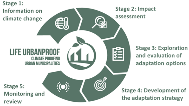
Stage 1: Information on climate change. Explore through interactive charts, information on climatic projections based on the greenhouse concentration levels of two Representative Concentration Pathways (RCP 4.5, RCP 8.5).
Stage 2: Impact assessment. Explore the climate change impacts on the urban environment and gain insight into the individual parameters (physical, structural & socio-economic) contributing to the creation of these impacts.
Stage 3: Exploration and evaluation of adaptation options. Explore available adaptation measures and their evaluation scores against a set of criteria OR provide your own evaluation of the adaptation measures.
Stage 4: Development of the adaptation strategy. Prioritization of adaptation measures based on the score they attained at Stage 3. The measures that gathered the highest scoring may be included in the local adaptation strategies of the municipalities.
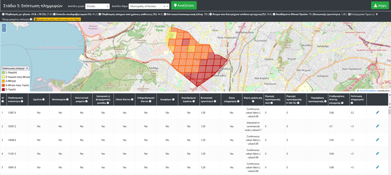
Stage 5: Monitoring and Review. Investigate the effect of the implementation of adaptation measures in increasing the resilience of a municipality to the examined impacts.
The tool is currently used to carry out impact assessment and adaptation for each urban municipality in Italy, Greece and Cyprus. Higher resolution data are provided for the municipalities of Reggio Emilia (Italy), Peristeri (Greece), Strovolos and Lakatamia (Cyprus) which are partners of the LIFE URBANPROOF project.

ADAPT TO CLIMA

GET participated as a subcontractor in the LIFE ADAPT2CLIMA: Adaptation to Climate change Impacts on the Mediterranean islands’ Agriculture to the effects of climate change. The aim of the LIFE ADAPT2CLIMA decision support tool, developed as part of this project, is to expand knowledge on climate change and its impact on the agricultural sector, to support farmers, policy makers and others. stakeholders (agronomists, agricultural industry, etc.) in decision-making to adapt to climate change.
The impacts of climate change on crop performance, water availability and the agricultural sector in general are presented through interactive visualization maps and graphs. In addition, the tool can be used to explore available adaptation measures to address climate change impacts, as well as their effectiveness in increasing agricultural resilience.
The main climate change scenarios considered are the average climate conditions expected for the period 2031-2060 based on the IPCC RCP4.5 and 8.5 emission scenarios and therefore the tool may serve long-term adaptation planning.
Moreover, extreme climate scenarios (dry, wet, hot, cold) were considered based on the RCP8.5 emission scenario, in order for the tool to be used for short-term adaptation planning by farmers, in case extreme weather conditions are observed in the near future.
The tool is implemented in Cyprus, Crete (Greece) and Sicily (Italy), but can be used by anyone wishing to develop a regional adaptation strategy for the agricultural sector, for the regions of Italy, Greece and Cyprus.
GET was responsible for developing the ADAPT2CLIMA tool based on the methodology and data provided by LIFE ADAPT2CLIMA partners. The application utilizes the technology and know-how of GET related to the management, visualization and analysis of spatial data as well as the ability to design and develop environmental IT tools.


PULCHRA

The National and Kapodistrian University of Athens in collaboration with GET successfully completed the implementation of the electronic platform PULCHRA City Challenges Platform. The implementation took place in the framework of the HORIZON 2020 Science in the City: Building Participatory Urban Learning Community Hubs through Research and Activation -PULCHRA program funded by the European Union. GET participated in the program as a subcontractor of the University.
The project is about developing an online environment for interaction and information, which will enhance synergies between different groups of stakeholders, such as schools, businesses, local governments, NGOs, etc. The design and development of the platform was based on the methodology developed in the context of PULCHRA project.
The PULCHRA City Challenges Platform supports an open network, which consists of schools and other stakeholders (universities and research centers, public and private sector bodies, central and local government bodies, NGOs, members of education etc.).
The development of the platform was based on the WordPress open source content management system, which is a powerful open source software for creating, managing and sharing content on the Internet and social media.
Different menus are available for presenting the content of the platform:
- Participant presentation menus (schools, teachers, other stakeholders, etc.) which lead to corresponding pages with more information for each participant
- Project presentation menus, which lead to corresponding pages with more information about the progress and results of the work.
- Project Partners Presentation menus
- Cartographic mapping of the schools participating in the project
Finally, individual tools were developed to support the working groups, such as:
- Online courses (external links)
- Educational material
- Repository of material (e.g. scientific texts, reports, etc.)
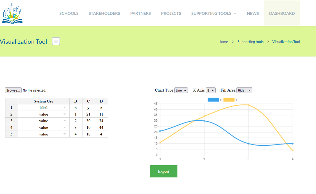
- Visualization tools – Visualization tool, for which the data to be visualized are given in a standard format, e.g. measurement data from sensors
- Remote Sensing tool – which provides access to Copernicus program data
- Newsletters / Posts by work teams (Science teams and Science Reporters)

NanoExplore

GET participated as subcontractor in the Life NanoExplore research project which is co-financed by the LIFE program for Environment and Climate Action (2014-2020). The Life NanoExplore project is working to develop and demonstrate the feasibility of an integrated approach to conduct biomonitoring studies, characterize exposure levels and elucidate possible health effects deriving from exposure to engineered nanomaterials (ENM) in indoor workplaces and urban areas.
NanoExplore promotes a harmonized approach to overcome current data gaps and barriers limiting the implementation of the REACH regulation and the use of human bio-monitoring data in the protection of human health and the environment when dealing with particles in the nanometer range (1-100 nm) by combining long series of robust data on the concentration of ENMs measured by a wireless sensor network (WSN) of monitoring devices, appropriate biomarkers, and a tailored designed data management application. This approach addresses current environmental, health, and safety questions about ENMs, providing stakeholders from government, industry, NGOs, or the general public, with reliable data on the concentration and effects of particles in the nanometer range (1-100 nm).
- NanoExplore will generate a panel of recommended biomarkers to support a harmonized health surveillance in the near future
- A major challenge within NanoExplore will be the definition of a robust monitoring system able to monitor relevant parameters, discriminate background levels, and identify operations modifying the exposure.
- The NanoExplore approach will be implemented in case studies from the Valencia community. Companies producing and/or using ENMs will be contacted to define a proper implementation plan.
- NanoExplore will generate new data on the particle concentration collected from the particle breathing zone (PBZ), supporting health surveillance)
GET undertook the development of the hybrid web-based multitenant platform of Life NanoExplore. The results were:
- The development of an intelligent environmental hybrid web-based platform which gathers data from different sensors, normalize, process and analyzing them.
- Provision of a multitenant platform that can be reused by other environmental projects setting an industry standard for gathering, analyzing and processing the different ENMs data.
- Enable different environmental projects and stakeholders to securely store, process, analyze, and share data together while, at the same time, make some of the data available to the public
SPACE 4.0 - Space Technologies and Applications 4.0
The GET is involved in the implementation of the research project entitled “SPACE 4.0 – Space Technologies and Applications 4.0”. The project is implemented within the framework of the program “Competitiveness, Entrepreneurship and Innovation (EPAnEK)” 2014-2020 – Action ” Innovation Clusters/ -2nd Tender: Enterprises “.
The “smart” collection, processing, management and analysis of satellite payload data – either during flight or on the ground – using combinations of modern space technologies with innovative artificial intelligence and machine learning technologies, offers new opportunities and possibilities, but at the same time poses challenges. The challenges relate to the development of innovative applications that strengthen important sectors of the economy (such as Smart Agriculture, Transport, Environment and Satellite Communications), increase the collaboration among enterprises, as well as enhance innovation, competitiveness and extroversion, especially in the current, difficult geopolitical and financial environment.
In this context, the available services and applications based on Information and Communication Technologies, aim at improving the quality of the citizens’ life, as well as their trust in institutions and the state. Achieving this goal directly depends on the quality of services provided by various entities and businesses, as well as on the effective support of decision-making in management processes.
SPACE 4.0 project focuses on the development of integrated, innovative and technologically advanced space applications and services. In brief the project aims at:
- Developing an innovative system for monitoring and modeling atmospheric pollutants. The system will be developed in such a way that will allow the management of the large volume of Earth observation data and the diverse data sources and formats, taking into consideration the need for specialized tools to analyze and process the data and other supporting in situ measurements.
- Developing an integrated chain of algorithms and methods to reduce the quantity, improve the quality and distribution of satellite payload data using space technologies (on-board data reduction and geolocation), but also the accuracy of Earth Observation results at the ground station, using artificial intelligence to monitor and manage port security.
- Creating an information platform for the interconnection of smart infrastructure in cloud, that will manage satellite payload data.
- Developing a smart sustainable agriculture management system through monitoring crop parameters from UAV arrays and available ultra-high resolution satellite data.
GET in collaboration with SPACE HELLAS and having as a subcontractor the Department of Environmental Physics and Meteorology of the National and Kapodistrian University of Athens, is responsible for the development of the innovative system for monitoring and modeling atmospheric pollutants.
The project supports the vision of the si-Cluster to develop and maintain a Cluster of International Scope and World Prestige, in the field of Space Technologies and Applications. The main objective of si-Cluster, also through this project, is to attract significant research and business activity to the country and to develop research and industrial excellence in specific fields of space technologies and applications in which Greece has demonstrated a comparative advantage.
The SPACE 4.0 Project is implemented by the cooperative scheme of the following ten (10) partners / companies:
- Space Hellas S.A. – Coordinator
- Geospatial Enabling Technologies
- Geosystems Hellas A.E.
- Satways
- Heron Engineering
- Planetek Hellas
- Softcom International
- Terra Spatium
- Axion AGRO
- MaP Ltd.
The project is implemented within the framework of the Action “Innovation Clusters” and is co-financed by the European Union and national funds through the OP. Competitiveness, Entrepreneurship & Innovation (EPAnEK) (project code: ΓΓ2CL-0343669)


