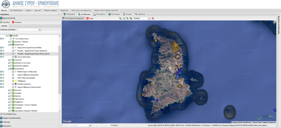
Spatial Data Infrastructure for The Municipality of Syros – Hermoupolis
The Municipality of Syros – Hermoupolis is another Municipality that has shown confidence in GET for the Development of its Spatial Data Infrastructure by choosing the GET_ICT solution, provided by GET within our portfolio developed for Smart Cities, with the aim of providing a modern web tool to the employees of the Municipality, to the professionals and to the citizens as well.
The Municipality of Syros – Hermoupolis had as priority the organization of the existing geospatial information, the development of advanced web services for the dissemination of the geoinformation to the public (citizens, professional engineers), but also the transfer of know-how to the Municipality’s executives, in order to improve internal geospatial data management flows.
Everyday life and contact with citizens and agencies demonstrated the need for modern and unified tools and methods of accessing information. In this context, the Municipality, with the aim of improving the efficiency of its services and better serving the citizen, invested in the creation of the necessary digital infrastructures through which it will be achieved:
- the enrichment of digital systems with new content
- the development of new applications
- the development of structures for interacting with users
- the provision of specialized/structured content
- the provision of support to services in order to cope with user requests for corrective/supplementary interventions
- the expansion of the base of internal users of the systems
- the sharing of data within the services of the Municipality and the creation of a common operational picture
In this context, GET has developed a modern geo-information system (GIS) for the management and dissemination of available digital spatial information. The system uses only free and open-source software, achieving huge resource savings, as the cost of acquiring and upgrading software licenses is zero.
The interested parties have the opportunity to receive information regarding the spatial organization, infrastructures, environment. The infrastructure includes over 250 items which fall into a number of thematic categories, providing access to geospatial data and standardized files. The data is available through the Geo Portal, which functions as the main user interface with the infrastructure, while the system’s thematic and operational scalability is potentially limitless.

TECHNOLOGY
- PostgreSQL
- PostGIS
- Quantum GIS (QGIS)
- Geoserver
- GeoWebCache
- Geonetwork Opensource
- GET SDI Portal
USEFUL LINKS
PROFILE
Name: Municipality of Syros – Hermoupolis
Website: https://www.syros-ermoupolis.gr/
The Municipality of Syros – Hermoupolis is a municipality of the South Aegean region that includes the islands of Syros, Gyaros as well as their neighboring islets. It was created with the Kallikratis Program from the amalgamation of the pre-existing municipalities of Hermoupolis, Ano Syros and Poseidonia. The area of the new Municipality is 101.9 sq.km and its population is 20,791 inhabitants according to the census of 2021. Hermoupolis was designated as the seat of the municipality, while Ano Syros was designated as the historical seat.


