Services and Applications for the Administrative Organization of Geospatial Data for the Municipality of Haidari
GET successfully implemented the project “Services and Applications for the Management Organization of Geospatial Data” for the Municipality of Haidari, which aimed at modernizing the means of organization, management and dissemination of geo-information.
The SDI that was developed, bases its operation on the creation of databases, where geospatial data of the Municipality were integrated. At the same time, updated digital photographic data were collected with the ability to make measurements on it, and were used to enrich the SDI with elements of urban equipment, such as waste bins, vertical marking elements.
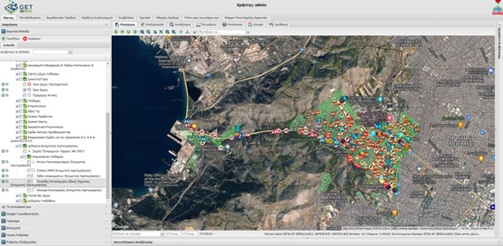
All data is made available through web services based on open standards, facilitating interoperability and communication with third party systems. Access to the data is provided through a Geoportal, which allows, among other functions, the visualization, downloading and analysis of the data.
The infrastructure currently includes 544 information layers, 400 Government Gazettes, 35,000 georeferenced panoramic images, 5 electronic services (viewing, downloading, searching, transformation, geocoding). The documents cover individual thematic categories, such as: City Plan – Implementation Acts, Building Terms, Land Use, Municipal property, Forest maps, Cadastre Land Parcels, Archaeological Cadastre, Urban Accessibility Plan, etc.
The system serves the internal needs of the Services of the Municipality, but aims mainly to serve the public (citizens, engineers, professionals, institutions) and to democratize access to information.
The users have easy access to the desired information through a dedicated web platform. Just with a single “click” anywhere on the map, the user retrieves a wealth of information regarding:
-
- Town planning regime (Town Planning – City Plan, Modifications, Building Conditions, Land Uses, Diagrams, etc.)
- Implementation Acts, Implementation Corrective Acts and their relevant diagrams
- Technical Reports, Implementation Charts, Actuarial and Endorsement Acts
- Cadastre Land Parcels
- Building Permits and Scanned Contracts
- Points of interest (such as: Vertical Road Signs, Traffic lights, Waste Containers, Lighting poles, Public transportation stops)
- Cartographic Reference Maps
- 360o panoramic images of the road network of the Municipality with measurement accuracy of 5cm
- Geocoded postal numbers
Special features of the system are:
-
- the connection and documentation of urban planning data with the relevant legislative framework, which was codified and is available through a relevant aggregated registry (~400 Government Gazette),
- the ability to download the original diagrams, as well as the other elements of the maps through the application, without having to visit in person the Services of the Municipality,
- The ability to measure in three-dimensional space on 360o panoramic images
- the ability to locate a property’s postal number
- Historicity in the retrieval of urban planning data for the area of interest.
The system evolves and is systematically enriched, being a key pillar of the digital strategy of the Municipality. The implementation of the geographical system has been based on the use of open-source software, achieving huge savings and ensuring the possibility of thematic and functional expansion.

TECHNOLOGY
- PostgreSQL
- PostGIS
- Geoserver
- GeoWebCache
- Geonetwork Opensource
- GET SDI Portal
- MX7
USEFUL LINKS
PROFILE
Name: Municipality of Haidari
The Municipality of Haidari is the largest, in terms of its area extend, in Western Athens. It has a total of 22,655 acres, where the extend of built-up area covers 4,457 acres. Today’s City of Haidari is the most historic settlement of Western Athens, whose main residential core was created around 1882. It is the first area of Western Athens to obtain an approved urban plan, while it has obvious signs of its historical continuity, which function semantically as poles of recognition, such as the Ancient Sanctuaries of Aphrodite and Apollo, the Cave of Pan, Palataki, the former German Concentration Camp during the German Occupation, the Church of Prophet Elias and the Monastery of Dafni.
.


