Development of Frost Warning App for Ministry of Agricultural Development
GET developed the application of frost warnings for the Ministry of Rural Development and Food, which aims to limit both the damage to the country’s crop production and the additional burden on the Hellenic Agricultural Insurance Organization budget as well as the state budget. The application is available in the cloud of the Ministry of Digital Governance and the development of the application for mobile operation will follow.
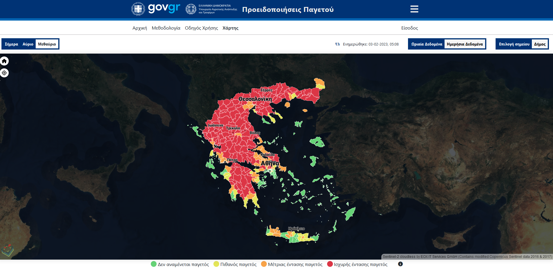
The application developed for the presentation of the warnings is web-based utilizing modern technologies for the development of interactive cartographic applications.
4 levels of warnings are provided through the application.
Green: There are no warnings for the selected area.
Yellow: Possibly Frost.
Orange: Medium Frost
Red: High Intensity Frost.
The interactive map shows the country divided in municipalities. Each municipality has the color of the corresponding warning level. Hovering the pointer over a specific municipality displays a text box with the name of the Municipality and the message corresponding to the warning level for the specific Municipality.
The forecast is based on weather forecasts from the European Centre for Medium-Range Weather Forecasts, which is the best in the world, received through EMY. Frost warnings are automatically generated from this data. The data is managed by a geographic information system that enables its presentation in the form of interactive maps or time series. The temporal and spatial analysis of the application makes it possible to monitor the phenomena hourly, while the user / farmer can focus and receive information exactly at the area his interest.
The application allows sending notifications to stakeholders using email messages. The application enables users to register for the specific service as well as to select the municipalities for which they are interested in for receiving notifications. When any warning is issued for a Municipality, a message is sent to the recipients registered for that Municipality. Hence, the producer is provided with the early and valid warning he needs to take the necessary protective measures before and after the frost.
In parallel, an application for mobile phones is also being developed, which will soon be available for mobile devices with Android or iOS software. The Application will provide the following features:
- User Login / Registration.
- Select municipalities to receive notifications for.
- Personal Notices. It will display the frost warnings issued for the municipalities selected by the user. Warnings will be reported for the next three days in daily increments.
- Distribution of Notice. It will enable the user to send the notification to other users using email.

TECHNOLOGY
- Html / CSS / Javascript
- Vanilla JS, MapLibre GL JS
- Geoserver
- PostgreSQL
- Python
- React Native
USEFUL LINKS
PROFILE
Name: Ministry of Rural Development and Food
Website: http://www.minagric.gr
Ministry of Rural Development and Foods is responsible for rural sector policy configuration concerning annual and perennial private and public investment programs. This ministry has many data, vector and raster, for the whole country.


