Application for Detecting Deformation in Urban Areas Using Differential Interferometry InSAR – Region of Attica
GET in collaboration with the TRE ALTAMIRA, who is the world leader in displacement monitoring services using satellite radar data, monitor and analyze the distortions in the urban fabric over the area of the Attica Region during the implementation of a confidential project.
The detection and mapping of areas with known or unknown surface deformation and the production of corresponding maps, which provide knowledge of risk management strategies, is a priority for the safe operation of infrastructure and the protection of citizens. Further monitoring of the marked areas is necessary both to predict their behavior and to validly identify “abnormalities” and take appropriate action where possible.
Potentially the characteristics that are exposed to danger can be point (buildings), surface (settlements) but also linear projects (pipelines, road projects, etc.), with the latter showing greater vulnerability due to their spatial planning and geometry. Many of the processes that cause landslides can extend over large areas and potentially affect overlying structures, so they should be considered both in the design of new projects in the area and during the operation of infrastructure for safety reasons.
Surface movements are a significant issue in the basins due to subsidence, and also the instability of the slopes in areas with a steep slope. The movement can be so severe that ground levels can change even at a scale of meters within a few years. This causes problems for the underground and above-ground pipelines, which are critical infrastructures for the supply of gas and water to citizens and businesses.
It is clear that the risk is greater when soil deformation worsens faster over time.
“Traditional” methods of mapping and monitoring surface vulnerability are based on field surveys. These methods mainly include geodetic measurements and / or intensive field work observations. However, these methods of monitoring surface deformation, not only provide spatial information only for limited points, but they also have many disadvantages, such as high cost and time consumption. At the same time, most of these monitoring systems require the installation of specialized equipment by specialists, which on the one hand is in many cases impossible due to the specific local conditions, and on the other hand are not able to generate knowledge about the behavior of the area in the past. (Historic Deformation).
Earth Observation satellites, a non-invasive source of knowledge, provide a very rich image database and different techniques for providing a range of measurements from space, enabling detailed recognition and monitoring of changes in the earth’s surface from several centimeters up to a few millimeters. The existence of the Copernicus Earth Observation Program nowadays gives free access to appropriate satellite data, making Differential Interferometry InSAR Services even more affordable.
In the context of the implementation of this project, utilizing a large number of available RADAR Synthetic Aperture (SAR) satellite data for the region of Attica and applying advanced techniques of Radar Differential Interferometry (SqueeSAR algorithm) a time series analysis was performed to emerge the deformation in the urban fabric and its evolution through time for the selected study period.
The results of the analysis include:
- Mean Deformation Velocity Map (in order to have an overview of ground movement across the area of interest)
- Time Series of Displacement, per measuring point (scatterer).
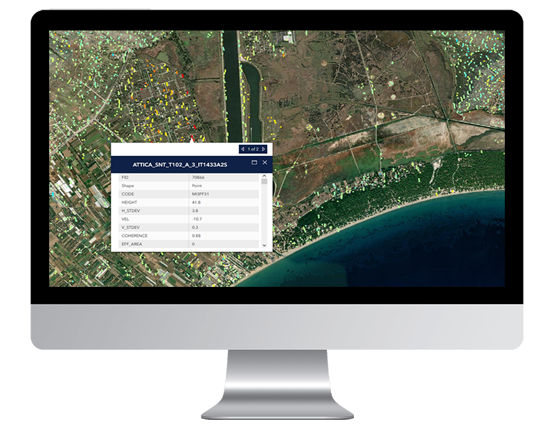
- The location of each measurement point (latitude, longitude, altitude) and its quality values (standard deviation and coherence, which give an idea of how reliable each individual point is) are provided in the SqueeSAR® database. The database can be easily imported into GIS software and visualized or delivered to our online platform
- The cumulative displacement. This is the mapping of the total shift that has occurred from the first satellite image reception to any sequential reception (from the second to the last).
- Mean acceleration, to indicate areas affected by increasing or decreasing velocity rates
- The periodic variation (seasonality), to highlight areas that show circular behavior.
- Differential displacement, to allow the mapping and analysis of displacements that have occurred between two individual satellite receptions (two distinct time periods).
The aim of the project is to identify and map the distorting displacement trends in the urban fabric and to create a reliable database for any future actions, aimed at the safe operation of infrastructure and the protection of citizens.

TECHNOLOGY
- GET SDI Portal
- GET Open Data
- Customized WordPress


