The research project “5D ARCHitectural AIr Documentation – 5D ARCH AID” funded in the framework of the HORIZON2020 European project UFO, is implemented by a collaborative group of four (4) partners: Asociatia Monumentum, JGC, HERITAGE MANAGEMENT e-SOCIETY (HERMeS) and Geospatial Enabling Technologies (GET) as coordinator.
Cultural Heritage is a high-growth sector, and EU leaders invest in heritage-led regeneration of urban and rural areas, enabling and amplifying Europe’s social and economic recovery. The vast potential of heritage-led regeneration in historic cities, villages and the countryside across Europe can indeed become a real game-changer towards a greener and more sustainable Europe.
In 5D-ARCH-AID, the consortium introduces a new innovative service that combines the well-established historic building documentation HERMeS methodology and SFOs’ technology on 3D reconstruction. 5D-ARCH-AID solution allows getting accurate results on pathology issues and conservation status of small/medium or large historic settlements, using drones and 360 cameras and provides an innovative tool that local authorities, NGOs, Research Institutions and SMEs could exploit to get quickly, low-cost, accurate data and information for conservation and protection of local cultural heritage.
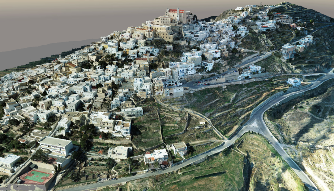
The 1st Milestone of the project was the creation of a rich digital representation of the historic settlement of Ano Syros, which led to the creation of a three-dimensional Digital Twin of the historic settlement and it was achived successfully on December 2022.
Photogrammetry is today one of the most widespread and accurate methods of geometric documentation, especially in complex objects such as settlements and cities, but also in areas where human access is impossible for the methods of classical Topography. Modern image photogrammetric products, orthophoto mosaics and 3D photorealistic surface models, combine geometric accuracy with the fidelity of visual information.
The state of the art topographic 3D background for the historic settlement of Ano Syros was created through the collection of new data from UAV and terrestrial data collection media based on 3600 moving panoramic cameras and high-precision scanners.
In particular, the following works took place:
- Production of the three-dimensional (3D) photorealistic model of the entire settlement of Ano Syros. The settlement was captured by aerial photographs taken from a suitable UAV (DJI Phantom 4 RTK) and then, with the necessary photogrammetric processing, the three-dimensional photorealistic model of the settlement was produced. In total, eighteen flight missions were carried out and 3286 photographs were taken, while the ground cover was 0.732 km2.
- Production of detailed 3D models of the 5 selected historic buildings. The selected buildings are the Cathedral of Agios Georgios, the Holy Monastery of Agios Ioannis (Capuchin), the Museum of Traditional Professionals, the house of Proveleggios and the former City Hall. The buildings were captured using powerful 3D laser scanners (Faro Focus M70 Scanner & Faro Focus S350 Plus Scanner), as well as the Matterport Pro2 3D camera ( https://my.matterport.com/show/?m=KE6CetxYmVC )
- Digital mapping of the network of routes within the settlement. The nature of the settlement did not allow the documentation – photography of the routes of interest using a moving medium and therefore the recording was done on foot. The GoPro Fusion camera was used for this task, which records through its two eccentric cameras, the space in the form of a 360-degree (spherical) 4K resolution image, as well as the Heron MS TWIN Color Scanner. This scanner scans while the user walks and every 10 meters the user stops to take a panoramic image to get the color information needed to add it to the created point cloud. A total of 9 trips were made and 4,896 of 3600 images were taken.
The 5D-ARCH-AID service is a tool for documenting the pathology of buildings and settlements, for creating conservation plans, shaping decision-making tools to prioritize interventions, and raising awareness of local communities in order to preserve their cultural heritage.
The 3D Digital Twin of the historic settlement of Ano Syros provides, among others, the possibility of 3D measurements remotely, while facilitating the perception of space and functions within the settlement remotely and can be the basis for decision-making in macro-medium and micro-scale.
The 5D-ARCH-AID implementation methodology hopes to significantly reduce the cost of cultural heritage documentation, while reducing implementation times without compromising on the quality of results.


