


Development of A Spatial Data Infrastructure and Open Data Portal for the Region of Attica
GET participated, as a subcontractor of the company NAMA Consulting Engineers and Planners SA, in the implementation of the project with the object “Services for the collection and mapping of Georeferenced elements of the urban furniture – property, of the road network of the Attica Region“.
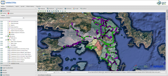
The project concerned the collection of georeferenced data of urban furniture – property, along the road network of the Attica region, which is within the range of property boundaries of the Attica Region, with the aim of creating a common operational picture, which will serve the organization internally as well as others public bodies, professionals and the public within the framework of 3882/10 and 4305/14 laws regarding the management and dissemination of information. The recorded data were integrated into the Geospatial Information Infrastructure and the Open Data Portal implemented by GET, which are based on free software (open-source software) and disseminated through open standards. These data concern all superstructures – street furniture, such as e.g. vertical and horizontal markings, signs, traffic lights, crosswalk markings, pedestrian crossing ramps, waste bins, lighting fixtures, benches, public transport stops, etc.
Specifically GET undertook and successfully implemented the following tasks within this project:
- Development of Geospatial Information Infrastructure / SDI
- Data Compliance Check with the INSPIRE Directive
- Entering data into the database and developing online services
- Generation of Metadata
- Interconnection and transition to the existing SDI and Open Data Portal
- Personnel training
The specific project was the first step for the digital maturation of the Region of Attica in terms of the availability and management of geospatial data, linked to the exercise of investment or construction activity. The implementation of an integrated solution for the management of elements of the built environment, as well as their monitoring, through the Geospatial Information Infrastructure is an integral element for the implementation of smart city applications. With the use of new technologies, the mass collection of large volumes of data can be achieved with great accuracy, as well as their efficient organization, visualization and dissemination.

TECHNOLOGY
- PostgreSQL
- PostGIS
- QGIS
- Geoserver
- CKAN
- Geonetwork Opensource
- GET SDI Portal
USEFUL LINKS
PROFILE
Name: Region of Attica
Website: http://www.patt.gov.gr/site/
The Region of Attica, as one of the main economic and cultural hubs of Greece, plays an important role in the administration and development of the country. The administrative responsibilities of the Regional Authority of Attica are varied and critical for the operation and development of the region. These include urban planning, transport infrastructure, environmental management, education, health care and social welfare services.
The Regional Authority of Attica acts as a central administrative body that coordinates these efforts and implements broader regional policies, as in recent years Attica has faced challenges such as urbanization, traffic congestion and environmental sustainability. Efforts to address these issues include strategic planning, infrastructure investment and collaboration between government bodies, local authorities and communities